The Neighbourhood Boundary in Your Head
A neighbourhood boundary in your head follows familiar routes and landmarks. Try a short observation exercise to spot where your map differs from a neighbor’s.
The most common mistake in drawing a neighbourhood boundary is treating a familiar route as if it were everyone’s dividing line. That can leave a nearby block feeling overlooked, or make a local discussion seem more settled than it is. A neighbourhood boundary in your head is built from daily movement, remembered landmarks, and the places you consider part of your routine—not just a line on a map.
Notice how those pieces fit together before deciding where your neighbourhood begins or ends. A short observation exercise can show why two people who live close by may describe different places, without either being mistaken. The aim is not to produce an official border. It is to understand what makes a place feel connected, and where those connections change.
Start with the route you actually use
A mental map often begins with repetition. You may walk the same street to a bus stop, cross a plaza on the way to work, or take a familiar path to a grocery store. Because those routes recur, their blocks can feel like the center of the neighbourhood even if they sit near its edge on a civic map.
That creates a common problem: the route becomes the whole map. Streets you rarely use can feel distant, even when they are physically close. The cause is not simply a lack of attention. A barrier such as a busy road, an awkward crossing, a steep slope, or a building with no public entrance can make a short distance feel like a separation.
Try naming the places you pass on an ordinary errand, then note what you routinely leave out. A paper map or a blank sheet is enough; mark the route, the turns you remember, and the places where you change direction. Avoid filling gaps by guessing. This makes the shape of your daily knowledge visible without pretending it covers every block.
When one landmark seems to set the edge
A station, school, library, corner store, playground, or large intersection can act like a mental anchor. People may describe the area as “near the library” or “past the station,” even when those phrases place the same street on opposite sides of a boundary. Landmarks help people explain where they are, but they do not always agree with one another.
The trouble comes when one landmark stands in for a whole area. A person who visits the library may treat it as a neighborhood center; someone who uses the station may orient toward a different set of blocks. A familiar landmark is like a bookmark: it helps you return to one place, but it does not tell you how the whole book is organized.
To check whether an anchor is doing too much work, ask what lies beyond it in each direction. Name the next place you recognize, and notice where your confidence fades. If the map becomes vague immediately after one landmark, your sense of the edge may reflect your routine more than a shared local boundary.
Why two neighbors can draw different outlines
People can share an address area and still have different mental maps. A caregiver’s routine may connect home with a school entrance and a nearby pharmacy. A night-shift worker may think in terms of a transit stop, a well-lit route, and a late-opening shop. Someone who relies on a wheelchair may experience a block with a curb barrier as disconnected from a destination that looks close on a map.
Different maps can also come from time spent in a place. A longtime resident may use a name that newcomers have not heard, while someone who recently moved in may rely on a district label from a rental listing. These names can overlap without matching exactly. Treating one description as the only correct one can turn a useful conversation about local connections into an argument over who belongs.
When a boundary differs, ask what route or place supports the other person’s description. Listen for a specific crossing, landmark, service, or daily destination rather than asking someone to defend an abstract line. That gives you something observable to compare and avoids confusing a personal map with an official boundary.
Use a short observation exercise to compare maps
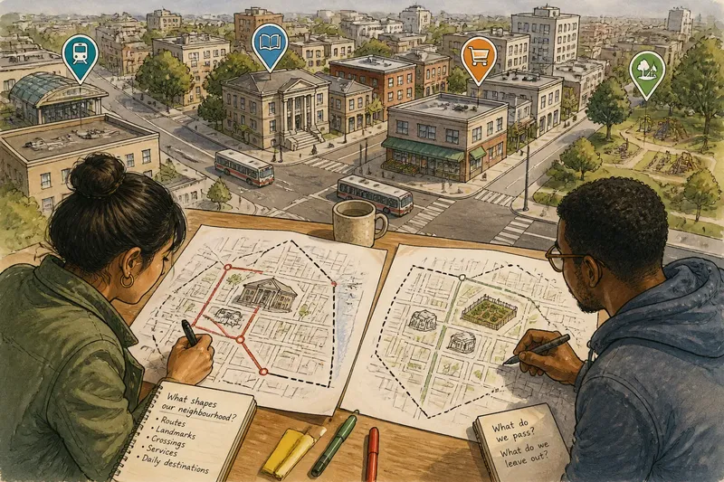
Try this on your own first, then invite a neighbor to make a separate map. Use a printed street map, a phone map, or plain paper. Work from memory before checking street names, so the exercise captures the routes and anchors that feel familiar rather than the border a map may already suggest.
- Write down a place you would use as the center of your neighbourhood, and name why it comes to mind.
- Trace a route you regularly take from home to a local destination. Mark the turns, crossings, and landmarks you notice.
- Draw an outer line around the blocks you would casually describe as “my neighbourhood.” Leave uncertain stretches open rather than forcing a boundary.
- Mark one nearby place you rarely visit, even if it appears close to your route. Note what makes it unfamiliar or inconvenient to reach.
- Compare your drawing with your neighbor’s. Circle a street or landmark that appears on one map but not the other.
- Walk or look at that point together, if practical, and describe what you can each observe: entrances, crossings, signs, activity, or a change in street pattern.
Say you usually walk from an apartment to a branch library along a main street, while a neighbor takes a side street to a community garden. You might each draw the library-side blocks as central and treat the garden route as an edge, even though the two destinations are close. Comparing the routes could reveal that a difficult crossing, rather than distance, is what separates the maps; the observable result is a clearer account of where each person’s sense of connection changes.
What should you do when your map does not match the street?
Should a mental map match an official neighborhood boundary?
Not necessarily. A mental map describes familiarity and connection, while an official boundary may define an administrative area or service district. Check the relevant city map when a form, service, or public process depends on the official line.
Why does a nearby block feel outside my neighborhood?
A road crossing, limited entrance, unfamiliar route, or different set of destinations can make nearby blocks feel separate. Note the specific point where your route or sense of recognition changes before deciding that distance alone explains it.
How can I compare maps without arguing over names?
Ask each person to trace a familiar route and identify the landmarks that shape it. Compare the places and transitions they mark, rather than trying to settle whose neighborhood name is correct.
What if a map misses a group of residents?
Ask whose routines are absent and which routes are difficult or seldom represented. Invite people with different schedules, mobility needs, and destinations to describe their own maps instead of assuming one drawing speaks for everyone.
Use differences as local information
A mismatch between two maps is not automatically a problem to fix. It can point to a street that feels like a barrier, a destination that serves as a shared reference, or a block that one person’s routine rarely reaches. Those details matter when neighbors discuss walkability, local services, or what area a community activity should reach.
Keep the observation grounded in what people can describe: the route they take, the place they use, and the moment a familiar area starts to feel unfamiliar. If you share the result in a local discussion, make clear that it is a personal map, not a claim to speak for every resident. A neighbourhood boundary in your head is most useful when it helps you ask better questions about how the surrounding blocks connect.
Next time a neighbor names a place as part of the neighborhood that you would have left outside, ask which route brings it into their map. That small question can reveal more about the shape of local life than a quick debate over where to draw the line.